Visitors to the Sandia Mountains will soon face extended closures near the crest as federal officials begin a major forest management project aimed at reducing wildfire risk and protecting critical infrastructure.The Cibola National Forest and National Grasslands issued a closure order for parts of the Sandia Crest area, effective April 30, 2026, at 6 a.m. The restrictions are tied to the “Switchback” Hazard Tree and Fuels Reduction Project, which will involve mechanized thinning across approximately 140 acres.According to Sandia District Ranger Ken Born, the work is necessary due to a buildup of dead and downed trees in the area.“The forests around the Sandia Crest contain a significant number of dead trees, both standing and down,” Born said. “A high-severity wildfire could damage or destroy critical infrastructure because of the high fuel loading around the Crest Communication Site.”The project will focus on land surrounding the Sandia Crest Recreation Area and the Sandia Crest Communication Site, both of which serve key roles for recreation and regional communications systems. Officials say the thinning effort will not only reduce wildfire risk but also create defensible space for firefighters and improve safety for visitors and staff.The closure includes several popular destinations and access points:Ellis TrailheadSandia Crest Recreation SitePortions of New Mexico State Highway 536 beyond the 10K Trailhead parking lot (just past mile marker 11)Officials emphasized that these closures are necessary to protect the public from hazards associated with heavy equipment operations and falling trees during the project.The order will remain in effect through Jan. 15, 2027, at 6 a.m., unless lifted earlier. Detailed maps, closure boundaries, and updates are available on the Forest Service website.
Visitors to the Sandia Mountains will soon face extended closures near the crest as federal officials begin a major forest management project aimed at reducing wildfire risk and protecting critical infrastructure.
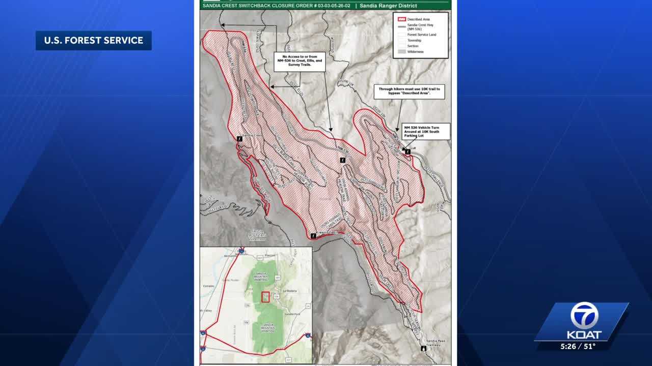
The Cibola National Forest and National Grasslands issued a closure order for parts of the Sandia Crest area, effective April 30, 2026, at 6 a.m. The restrictions are tied to the “Switchback” Hazard Tree and Fuels Reduction Project, which will involve mechanized thinning across approximately 140 acres.
According to Sandia District Ranger Ken Born, the work is necessary due to a buildup of dead and downed trees in the area.
“The forests around the Sandia Crest contain a significant number of dead trees, both standing and down,” Born said. “A high-severity wildfire could damage or destroy critical infrastructure because of the high fuel loading around the Crest Communication Site.”
The project will focus on land surrounding the Sandia Crest Recreation Area and the Sandia Crest Communication Site, both of which serve key roles for recreation and regional communications systems. Officials say the thinning effort will not only reduce wildfire risk but also create defensible space for firefighters and improve safety for visitors and staff.
The closure includes several popular destinations and access points:
- Ellis Trailhead
- Sandia Crest Recreation Site
- Portions of New Mexico State Highway 536 beyond the 10K Trailhead parking lot (just past mile marker 11)
Officials emphasized that these closures are necessary to protect the public from hazards associated with heavy equipment operations and falling trees during the project.
The order will remain in effect through Jan. 15, 2027, at 6 a.m., unless lifted earlier.
Detailed maps, closure boundaries, and updates are available on the Forest Service website.