Hurricane Gil has formed in the eastern Pacific
Florida. I’m West to meteorologist Eric Burris. And in *** very hot Savannah, Georgia on WJCL 22 chief meteorologist Jeremy Nelson. So Jeremy, it may be hot in your area. It’s hot in mine. We had 98 yesterday in Orlando, 99 at the kind of downtown airport, and we’ve had one of our locations hit 100 degrees two days in *** row. So it’s, it’s definitely hot across the deep South, I would say. Yeah, yesterday in Savannah, we hit 100 degrees and, and then someone, of course, commented, it’s hot here every. Summer and I go, well, it’s not 100 degrees hot, but it was over 3 years since we had hit 100 here. So this is *** pretty significant heat. Yep, yup. And I mean it, it can happen every summer, but the thing is it doesn’t happen every day. And so as meteorologists, it’s definitely our job to communicate those threats. But one thing that has not necessarily been hot has been the tropics. There have been *** few named storms, but over the last few weeks, thankfully, there has been really nothing to track. It’s been quiet out there and it’s just been, it’s been like 2 months of dust in that main development region and it’s just been so quiet there, squashing anything, dusty dry air is not conducive to tropical development, but now we do have at least *** couple of tropical waves out there, those areas in red and in off the west coast of Africa. Those are clusters of thunderstorms and That’s what we start watching this time of year out in that area. That’s right. We’ll zoom into it just *** little bit here just to kind of give you an idea. And that’s the main development region. This does not have any kind of an expectation of developing from the National Hurricane Center. Their official forecast is that there is no development over the next 7 days’ time, but We’ve seen these kind of monsoonal troughs, while they may not be organized and may not be expected to develop, the one thing that’s interesting about it, Jeremy, is the fact that they’re, they’re presenting themselves, which at the very least is an indicator that we’re kind of progressing toward that kind of peak of hurricane season regime. Yeah, and one thing we can watch with these, well you just mentioned, short term, probably no development with these, but sometimes even if they’re not going to develop out there, you can sort of keep that little tropical wave or spin going as it nears the Caribbean or the Gulf or somewhere in the southwest Atlantic, and then maybe that’s when its opportunity would come to try to form into something. But at least maybe the next 5 to 7 days, nothing is highlighted at this point, which would take us into the first few days of August, right, right, right. So we’ll put this up there, the official forecast from the National Hurricane Center, no development over the next 7 days’ time, but you had mentioned that, you know, we kind of get into August for that potential. And when we look at the data, right, we know that it is during the month of August that we really ramp up that tropical coverage. So, uh, when I was doing my coffee talk broadcast to our West 2 viewers this morning, um, you know, somebody had mentioned, well, it’s August, that’s when things typically get going, and it’s like, Yeah, we’re we’re not hyping it. We’re simply saying that there are indicators, and definitely on model data which you and I are going to discuss, but there are indicators that things are starting to wake up just *** little bit. Yeah, and, um, typically we look towards the, the longer range computer models. And last night, I mean, I think any meteorologists, their eyes kind of like, whoa. I mean, we’ve had some stuff showing up here for *** few days now, longer range, but I would say last night’s European, uh, run was, uh, probably. Uh, maybe the one of the more significant longer range forecast models we’ve seen, we’re not saying that, hey, that’s exactly what’s going to happen. But from the European model, which hasn’t been excited about really anything so far this hurricane season, it’s something we’re going to watch closely. Well, I suppose it would be *** good time to show that model then. Yes. And, and while you’re getting, while you’re getting that dialed up, let’s, let’s also sort of preface this with, remember late May early June, the GFS model. Wow, in the longer range, that was really trying to show something and what happened. Nothing. So these, these things can happen, but for the European model to try to latch on to something now and we’re getting closer to the start of peak season. I would say it’s definitely piqued our interest. Yes, OK, so let’s do this then. I’m going to pop up the European and, and, you know, this is *** situation where we are isolating one run of one model. I hate, I hate when people do this, but, but we’re going to use this as *** jumping off point to show current data, OK? Does that, does that sound like ***, like *** fair thing to do, Jeremy? Yeah, and we can also talk about the uh ensembles too and we’ll show different models. 100%. So let’s do that. All right. So let’s do this. This is last night’s European, this is the 00 Z. So it’s technically this morning, all right? This is what you’re looking at is 2 a.m. on Thursday, August 7th, and I’m gonna roll through time. Watch how it’s developing an area of low pressure off the southwest coast of Florida. And then bada bing bada boom. It not only develops something heading toward Louisiana by about the 13th of August, but it also has something kind of off of our east coast as well. Now, again, this is one run of one model. You probably are seeing this in the hyping machine that is social media. So now, let’s discuss what you’re looking at, and then we can look at the current runs of stuff. Yeah, and who knows? Maybe reality is down the road that you don’t get two things that look like this, but maybe one of those features will end up, um, sort of playing out and the location again, certainly would be uncertain, but there’s *** few factors that are. Starting to line up as we get into that maybe 2nd or inching towards the 3rd week of August. Yeah, yeah, we, we know that obviously the weather pattern kind of cycles itself around. We know that we can observe and kind of understand what’s more favorable. So with that said, then, the euro is going *** little bonkers on the extended, but let’s step back. OK, and let’s look at all of the model data together. So, let’s start by the current GFS run, and then we’re gonna look at the current European, and then we’re gonna look at the ensembles, OK? So, the current run of the GFS is nice and quiet around us for now, and I’m, I’m kind of omitting the open Atlantic. But I want to point out right in here, this is August 3rd, and I want you to look around the Greater Antilles. Do you see right there, Puerto Rico over toward Hispaniola? That’s, again, that’s 20 a.m. August the 3rd to 8:00 a.m. August the 3rd. There’s *** little piece of energy there, and it kind of crosses over, we call it the hurricane graveyard, and we call it that because you can kind of see this little feature, at least according to the GFS is going over *** bunch of land. It’s not going to let it develop into much, but it’s trying to show at least *** broadened Area of low pressure, and then from there, nothing really gets going at all, and I’m gonna take it all the way through. Though you notice around August 12th, look around Louisiana. Do you see that there, Jeremy? There’s, it’s broad and unorganized, but there is an indicator of lowered pressure around Louisiana. So while the GFS isn’t necessarily going all in like the European was, it still has *** hint of something in that spot in that same time frame. Yeah, and that’s what we’ll start to watch as we get closer and closer and closer to the models, uh, get closer to each other, merge *** little bit, or do they diverge, and, and one is like still hanging on to that tropical system. Another one’s like, no, nothing’s going to form. *** long ways out, but that probably leads us into the ensembles here where we get all, we get each model running several different versions. Right. So we’re going to take this is the GFS and again you can see there’s *** subtle hint of something there, and we’ll just kind of go through. So let’s back this up and we’re going to look at the GFS ensemble product. And what the GFS ensemble is, think of it, and I’ll, I’ll just kind of show you the panels for pressure, all the members. So this is the GFS model, OK? The GFS has 30 different members and what you’re looking at is all 30. Different members there, OK? So, each one is basically it runs the GFS that we know and love, then it goes back and reruns these 30 different, they call them ensemble members, where we basically just turn the dynamics around *** little bit and you get 30 different flavors of Baskin Robbins. We put it all on top of itself, just to kind of get an illustration, and I’m gonna come back out to *** slightly wider view, and we’re just gonna roll through time. So if you see like 30 different hurricane looking things, it’s not that there’s 30 different ones, it’s just that there’s the different ensembles. But if you notice here, let’s just pause this, this is um 2 p.m. on Monday, August 11th. You see there are several circles around, one is near South Texas, one is in the Central Caribbean, one is out near Hispaniola, one is uh outside of the Bahamas, one is over near Bermuda. Those are different ensemble members saying. Maybe an area of low pressure here. Out of 30, you’re looking at like 5 or 6. So there’s some ensemble support of something, but notice through time, this is all the way toward the end, no, go ahead. To be honest, that’s probably, I mean, to us, that’s not very impressive. No, it’s not, it’s not at all. It’s not, right? So, so there’s that, um, but let’s go back and let’s look at the European ensembles, OK? All right, and the, the current euro only goes out 144 hours, so we, that’s the 60s, so we have to go to the 00Z, which is the one Jeremy and I showed at the very beginning, and notice that’s Wednesday, August 6th, there’s *** little ensemble support around Florida, and then notice there’s *** whole lot more. Kind of like little hornets from from the Caribbean to Cuba, to outside of the Bahamas to north of Puerto Rico. So there’s definitely ensemble support, again, that’s the 00Z, of something around in August. If I go back to the 12Z run, which is Going to be the previous long range run, not as many ensemble members showing something, but it’s there. So the European is at the very least trying to sniff something out, maybe even several things out, um, in that first couple of weeks of August. Yes, and uh as we get *** little bit closer, we’ll start to get really once you get within about what is it like 240 hours we can start incorporating in. Uh, *** lot more, uh, various models for some of the ensembles and, um, we’ll be able to get *** little better idea. But, uh, with the European there, you showed, you were talking about like August 6th or something and also on some of the operational runs, they’re trying to put some sort of low, doesn’t look impressive, North Central, maybe northeast Gulf. And that, I believe in our long range forecast, we had August like 2nd to the 7th in that area. Probably not going to be development. We’ll keep an eye on it. Um, but all those little lows that have been around recently have been within our forecast. So that’s why we say not every time when we highlight *** day is something going to develop. However, those are clues because we’re going to hit some of these parts of the pattern another 1 or 2 times. And that’s going to be in peak season, so I think I don’t write this hurricane season off by any means. No, my gosh, no, no, not at all. And you had mentioned the clues, so let’s take *** moment and, and talk about maybe *** piece of the pattern that didn’t exactly roll into our long range forecast, but that we’ve observed since, and that’s kind of what had yielded Sean Tall this year. Talk about that. Yeah, OK, so when Sean Tall formed around the 4th of July, give or take *** couple of days there. Uh, we started, it definitely piqued our interest, and then we went back through, um, the cycle, which we know and we’ve been talking about this, I feel like forever now, keeping in mind our, our forecast is released the last day of. February. So we know probably plus or minus *** couple of days from about 40 days is the duration we’ve been really interested in. So you go back to May 26th, 28th. Well, yep, there was that low right off the, the southeast coast. It moved up towards kind of the Myrtle Beach area somewhere in there and then. And it came back July 4th, 6th. It was *** tropical system. Well, now we’re looking ahead to around August 12th to 15th, and then this is really piquing our interest because, well, what has some of the ensemble data been showing? It’s been showing maybe *** ramp up in activity. Yeah, so to that point. It’s not necessarily *** part of the long range forecast that we put out in February slash March, uh, but it’s an area that we’ve started to observe over and over again. And so we’re just kind of highlighting that as, as *** piece of the pattern that we’re, you know, more than likely going to be observing and, and kind of going from there. Yeah. And what people don’t see is behind the scenes, Eric was like scrambling last second to get this done. So yeah, those are the dates, and I think September we had, um, I’m looking at my, my little Eric hates list, right? My actual old school notes. And, and I wrote down, I think it’s the 2, like the 21st, 25th of September. You guys get the idea. These dates are kind of within *** day or so of the range. But yeah, it’s like the 21st, the 25th of September, what he showed there, the 12th to 15th of, um, August and then the 4th to 6th of July is when that was, uh, off the, off the coast. So, that’s kind of what we’re looking at there. So that, that is one. Um, another piece of the puzzle for this season. And that’s also why I think it’s important, Jeremy, like we, whenever we talk about our forecast, we’re never going to sit here and say that if you’re not in *** hotspot, you’re not gonna get hit. We just simply are trying to highlight areas that seeming. Seemingly behave like it should be *** higher than average threat for landfall, um, right, which, which, you know, we’ve had great success with it, but we, we, we know that this is not *** perfect science. Whether in our lifetimes will probably never be *** perfect science, but we’re doing our best to highlight, and I think we’re doing pretty great, um, but if you look at the, the lemons, so to speak, from the National Hurricane Center this year, those yellow highlighted areas. *** lot of them have been in the Gulf. They haven’t been out. They haven’t been out in the main development region, haven’t really been in the Caribbean *** whole lot. They’ve really been kind of hanging around Florida to the Gulf. I would still say no matter what, I still believe that the Gulf and, and once we get into that main part. Of the hurricane season, I still believe the lion’s share of activity will be from the Gulf. And I still believe that Louisiana to about the Florida Panhandle probably has the highest threat um of activity. But we’ll, you know, we’ll still see how this plays out. Um, hurricane season is just starting to really ramp up into August. Yeah, and so we’re almost done with July, and you think about it, June and July, you add that up only 12%. Of all named storms since 1851 have occurred during the first two months. So that is, I think at least for name storms, we’re on track, we’re below with some of the other metrics, but, uh, let’s see what happens in August. What, what, what was it? August, maybe like 23 years ago or maybe longer now, but Uh, 23 years ago where we had not one storm in August. Yes, and, and it was kind of like this, gosh, it would probably be 2-3 years ago, but it became like this game of like, are we gonna be at the slowest August ever, you know, and then all of *** sudden, what happened? Mother Nature was like, ah, I’ve got all this energy to release and just fired it off like it was chaff off the back of *** fighter jet. Yeah, so it got, uh, it got busy after that. So just because again, We’re starting off maybe *** little quieter in, in some of the metrics, uh, don’t think that that’s going to continue the entire season. Plus, you think about maybe bigger scale or larger scale parts of the atmosphere, um, with NOAA’s forecast, again, that doesn’t necessarily directly mean exactly what will happen, but the later you get into the summer and into the fall, some of these winds may In the upper levels start being *** little more conducive to development. Well, and, and that’s why those periods of time are typical for tropical development. So I think for right now, you know, the biggest point is we’re looking, there’s not really anything organizing on the tropical satellite. Love that. And yes, Bruce says there’s that key word again. I know. It’s always like *** struggle. To mention the word quiet, right? I get that. But um this, it’s late July. Things are not going to stay quiet for forever. We know this to be the case. So for those of us that are watching in here, we need to make sure that we put the work in. We need to make sure that we’re ready. That way when there’s something that threatens, because inevitably, Every season in your area, my area, we’re going to have to um at least sit on pins and needles at some point in the season, right? So, let’s make sure that we’ve got ourselves prepped and ready to go, and Taylor with the newspaper, stop saying the cue word. I get it. I get it. That must be *** big thing with. down there, they don’t like it. It’s because it’s because it’s like don’t poke the bear, right? Like we know, we know what happens when Mother Nature is like, all right, I guess it’s time to wake up, you know, we know what happens. We’ve all done this long enough, you’ve done this long enough, Jeremy. It is what it is. So I did have *** question. I have *** question here. Maybe you can help with this one here. So William was asking, does the hurricane season have *** new cone this year? And is that, is that where the National Hurricane Center kind of recalculates their accuracy, or is this talking about like the land-based watches warnings? Yeah, I mean, so every year they recalculate the width of the cone and it’s based off of their error over the last few years’ time. So every, you know, It has consistently been getting smaller, um, you know, and there’s gonna be some adjustments and things, but yeah, every year that is revisited. Last year they added to the forecast cone on their website, Inland watches and warnings, because as it’s crossing over land masses, the hurricane center more wants us to focus on impacts, as opposed to where the center of circulation goes because time and time again, they find that um People that focus on the cone over land completely lose sight of what the actual impacts will be, which is another reason why Jeremy, the the hurricane center has pulled back from using the Safer Simpson scale *** ton because they don’t want people to focus on. On *** category as much as it’s the impact. And I think that that’s been the overall trend in tropical forecasting is trying to focus more and more on impacts because impact-based forecasting is talking directly to the consumer, talking to you, talking to I, right? Letting us know. And I think last year that it was great they did that because with Hurricane Helene, while it made landfall in Florida, look at how far north those like significant impacts made it in populations. So you’re talking about something probably like 500+ miles away that had, if not hurricane force winds very close to it, significant flooding. And *** lot of those impacts that you may think are just near the coast were those so far inland last year. Well, and my brother Frank even mentions he’s over on the west coast of Florida and he references we were nowhere near the cone of Helene, and we got an 8 ft storm surge, right? That’s why I, you know. I say *** lot, right? Like, meteorology is not an exact science, um, especially because you have to translate it into the social science of how *** consumer receives it. So I think that that’s what we’re always the cone is only 20 something years old. Before that, it was kind of just like, it’s gonna go that way, you know, so it’s like we’re trying to always update how we do this, um. Yes. And Brian even mentions inland impacts can be very severe, sometimes as bad as the coast. It’s different too. Like, you’re not gonna get *** storm surge if you live in Orlando, but tell that to the people that got the flash flooding. So now you’ve got fresh water inundation. And it’s just to, it’s *** totally different bird. That’s why we have to focus more on impacts, right? Yeah, with, with Debbie in our area, after it made landfall down in Florida, it weakened so quickly, but we still had over 10 inches of rain and we had significant River flooding. Some communities flooded in our area. So that wasn’t really *** wind event for us. That was all about what you’re talking about with flooding. Right, right. Well, and then like, I know it sounds so silly, but, you know, Savannah has such beautiful tree canopy. Central Florida, different types, but has such beautiful tree canopy. You know, you get *** good wind and you bring power lines down, and I know that This is like *** first world problem thing, right? But widespread power outages cause their own set of hardship and cause that, you know, and so it’s like, yeah, coastal areas are probably gonna have more underground power lines. They’re doing more and more of that around the rest of town, but it’s all *** part of the big machine of like, when our life is not normal, it’s *** hardship, even if it is *** first world problem. Well, with Helene here, I think, uh, almost the entire area was without power and some of our inland locations and rural areas were without power for more than 2 weeks. That it was so hot after, after Helene. We did not get *** break from the heat. Sometimes you cool down with those systems that are like late September around here, but that was not the case. No, no, isn’t that something. All right, so we’re quiet for now. I think that’s the bottom line. But we’re not going to be quiet for long. I have *** feeling, Jeremy that our next tracking the tropics on Tuesday, we will absolutely have some model indicators of things. We’re, you know, now another thing, and I’ve said this before, and Jeremy, you’re, I know I’m gonna make you laugh here. You’re never gonna hear Jeremy and I say things like, hurricane signal, major indicators from the model. You’re not gonna hear us say that ever. That’s why I kind of like, we kind of put our blueprint out ahead of time. Yeah. Um, and with the Chantal update today, we kind of went back and we’re like, you know what, well, here’s *** little, *** little addition or something that we’re just gonna kind of update *** little bit. The, the rest of our dates are, are kind of laid out. And so far we’ve had the disturbances. We haven’t had tropical development in some of those windows, which we’re happy about, but yeah. We just kind of put it out there and and then if something does look like it’s going to form, we’ll obviously be letting you know. But we’re not going to be hyping it. We’re not going to be, you know, we’re not doing this to sit here and try. Jeremy, how much money do you get in your pocket from doing this track in the Tropics broadcast? Uh, nothing. Right, right. No, I mean. Yeah, well, we, we are employed by our TV stations. We are doing this for our employers, but we’re not sitting here trying to make *** ton of money by getting hypey clicks. And so to that point, I, I will say like, you’re not going to get hype from us. We are two meteorologists that have *** passion for. Tracking the tropics and I want you to understand that when we have this and it is *** two-way street, it is *** two-way conversation. When we have this conversation, our entire goal is to get you informed, to keep you up to date about model trends, model data, and the season as *** whole, going over our long range forecast. What we’re not going to do is be like, hold on. We have ***, you know, we’re not gonna do that, and I feel like social media has become that. Sorry for the extreme close up. And, and um I’m almost fearful to go look around much on social media today because I’m sure there’s going to be just uh images of that run last night that are out there and and kind of floating around. You’re not going to get that from us. No, and, uh, OK, so one thing I want to mention here before we wrap up, um, my weather team and station has *** severe weather expo really focused on kind of the peak of hurricane season coming up. It’s *** huge thing that, uh, and it’s going to be at Home Depot on the south side of Savannah. So there’s two locations. Uh, the south side is on Abercorn Street here in Savannah, and that is Saturday. August 2nd, so coming up here from 8 a.m. until noon, so you can, if you want to stop out there, I’m happy to talk tropics. We have *** lot of cool things going on. We have some giveaways. There’ll be some prizes out there, but, uh, like Georgia Power, who does all our power around here, they’re bringing their equipment out. So if the kids want to come out, see all that, the American Red Cross will be out there. SeeA, who is the Chathamer emergency Management Agency here. Yeah, for my county, we’ll be out there with some of their stuff, and it’s kind of *** big to do, but we’re just getting you ready for the peak of hurricane season. I love that. I love that. I love that. We’ve done *** bunch of things in Central Florida. I don’t have anything this weekend, which is good. It’s my son’s 5th birthday, so we’re going to celebrate that, but love that, love that. All right, do you have anything else, Jeremy? That is it for now, and I think next week uh. Be *** little busier. Yeah, we’ll be *** little busier. All right, well, from blasted hot Central Florida, I’m West to meteorologist Eric Burress. And in Savannah, Georgia, I’m WJCL 22 chief meteorologist Jeremy Nelson. See you guys. See you.
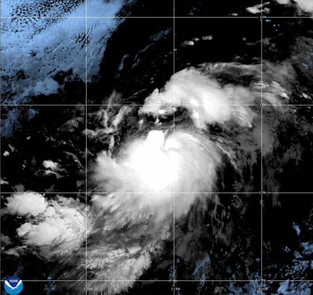
Tropical Storm Gil strengthened into a hurricane in the eastern Pacific Ocean on Friday but was not expected to threaten land, forecasters said.The Miami-based U.S. National Hurricane Center said the storm was about 1,080 miles (1,740 kilometers) west-southwest of the Baja California peninsula of Mexico.Video above: Tracking the Tropics: What could we expect heading into August?Gil had maximum sustained winds of 75 mph (120 kph) and was moving west-northwest at 20 mph (31 kph).No coastal watches or warnings were in effect. The storm was expected to keep traveling to the west-northwest in the coming days.Gil was strengthening during a busy period for storms in the eastern Pacific.Video below: This hurricane season, plan to prepareAnother named storm, Iona, which also was once a hurricane, was downgraded from a tropical storm to a tropical depression as it moved far to the west of Hawaii. It, too, was not threatening land.Other storms could develop in the coming days in the eastern Pacific, forecasters said.
Tropical Storm Gil strengthened into a hurricane in the eastern Pacific Ocean on Friday but was not expected to threaten land, forecasters said.
The Miami-based U.S. National Hurricane Center said the storm was about 1,080 miles (1,740 kilometers) west-southwest of the Baja California peninsula of Mexico.
Video above: Tracking the Tropics: What could we expect heading into August?
Gil had maximum sustained winds of 75 mph (120 kph) and was moving west-northwest at 20 mph (31 kph).
No coastal watches or warnings were in effect. The storm was expected to keep traveling to the west-northwest in the coming days.
Gil was strengthening during a busy period for storms in the eastern Pacific.
Video below: This hurricane season, plan to prepare
Another named storm, Iona, which also was once a hurricane, was downgraded from a tropical storm to a tropical depression as it moved far to the west of Hawaii. It, too, was not threatening land.
Other storms could develop in the coming days in the eastern Pacific, forecasters said.

