CURRENT CONDITIONS | CURRENT WATCHES AND WARNINGS | LIVE RADAR | UPLOAD YOUR WEATHER PHOTOS | TURN ON WEATHER NOTIFICATIONS A strong winter storm is set to bring rain, ice, and snow to New Mexico over the weekend. Depending on where you live, the impact will vary. In eastern New Mexico, ice accumulation is possible in southeast New Mexico before precipitation transitions to snow. The main focus of the snow will be in eastern half of the state, along the I-40 corridor. A winter storm warning has been issued ahead of the storm for many areas of the state. Tracking power outages in New Mexico | View road conditions in New Mexico | See the latest school closuresLive winter storm updates11:19 am – Officials in Otero County say in a social media post that a major power outage in the mountainous areas of Otero County has been reported. Officials say they have been told by the electric cooperative that the main power line that goes from Alamogordo to the mountains is down. There is not an estimated time for restoration. 10:51 am – Officials in Ruidoso tell KOAT more than 80% of the town is without power. City officials say many of the issues in Ruidoso aren’t related to snow, but related to ice accumulation. 10:38 am – Viewer video shows trees covered in ice are falling on top of cars and buildings in Ruidoso10:30 am – U.S. Highway 54 has been closed near Carrizozo due to multiple accidents on the highway. 10:00 am – More than 10,000 are without power in Lincoln and Otero Counties as a winter storm brought heavy snow to the southern mountains. Winter storm warningA winter storm warning has been issued for northern and eastern New Mexico ahead of a winter storm that’s set to bring snow, ice and cold temperatures to the state. Areas around Taos, Santa Fe, Los Alamos, Moriarty, Las Vegas, Santa Rosa, Fort Sumner, Tucumcari, Ruidoso, Roswell, Clovis, and Portales are in the winter storm warning. Winter storm warning: Snow amountsSnow amounts for those under a winter storm warning could range between 4 and 8 inches across much of eastern New Mexico. Areas above 9,000 feet could see between 8 and 16 inches of snow. Winter storm warning: Road and travel impactsTravel could become difficult to near-impossible along Interstate 40 between Tijeras to Santa Rosa to the Texas state line. Albuquerque impactsA Winter Weather Advisory has been issued for Albuquerque from 2 p.m. Saturday to 8 a.m. Sunday. Snow accumulations in the Albuquerque could range from 1 to 3 inches in areas below 7.500 feet with higher amounts in the Foothills. Slick roads are possible, including on Interstate 40 and Interstate 25 as the storm moves through. Rain showers through Saturday morning are expected to transition to snow by the afternoon and evening when snow levels drop.Ice accumulationFar eastern New Mexico could see freezing rain and ice accumulation Friday night and into Sunday morning. Rain is expected to change over to freezing rain and sleet late Friday night and into Saturday morning. Ice accumulations will be greatest near the Texas border where up to 0.05″ of ice is possible. Ice accumulation on power lines and tree limbs raise the risk of power outages. Electrical grid impactsThe National Weather Service is warning of possible outages as accumulating snow could stress the power grid. Areas under a winter storm warning could see power outages if heavy snow stresses the power grid. Temperature impactsBitterly cold temperatures are also expected with the winter storm. The coldest temperatures will impact eastern New Mexico with the coldest temps seen on Sunday morning. Parts of eastern New Mexico should prepare for 48+ hours of below freezing temperatures. The risk of hypothermia and frostbite are also elevated as cold temperatures set in for New Mexico. Be sure to download the KOAT App to receive customized weather alerts. You can watch the latest forecast on the app, too.Check Live, Interactive RadarLive Weather ConditionsSevere weather alerts for your areaDownload the KOAT App on iPhoneDownload the KOAT App on Android
CURRENT CONDITIONS | CURRENT WATCHES AND WARNINGS | LIVE RADAR | UPLOAD YOUR WEATHER PHOTOS | TURN ON WEATHER NOTIFICATIONS
A strong winter storm is set to bring rain, ice, and snow to New Mexico over the weekend. Depending on where you live, the impact will vary.
In eastern New Mexico, ice accumulation is possible in southeast New Mexico before precipitation transitions to snow.
The main focus of the snow will be in eastern half of the state, along the I-40 corridor.
A winter storm warning has been issued ahead of the storm for many areas of the state.
Tracking power outages in New Mexico | View road conditions in New Mexico | See the latest school closures
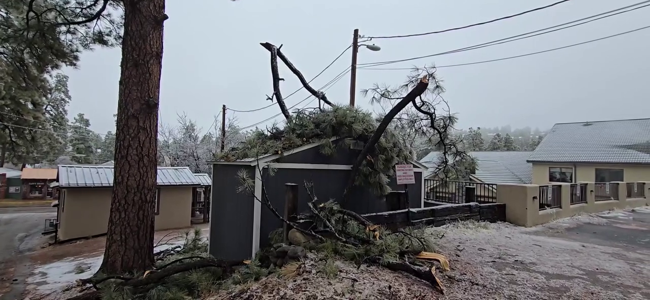
Live winter storm updates
10:51 am – Officials in Ruidoso tell KOAT more than 80% of the town is without power. City officials say many of the issues in Ruidoso aren’t related to snow, but related to ice accumulation.
10:38 am – Viewer video shows trees covered in ice are falling on top of cars and buildings in Ruidoso
10:30 am – U.S. Highway 54 has been closed near Carrizozo due to multiple accidents on the highway.
10:00 am – More than 10,000 are without power in Lincoln and Otero Counties as a winter storm brought heavy snow to the southern mountains.
Winter storm warning
A winter storm warning has been issued for northern and eastern New Mexico ahead of a winter storm that’s set to bring snow, ice and cold temperatures to the state.
Areas around Taos, Santa Fe, Los Alamos, Moriarty, Las Vegas, Santa Rosa, Fort Sumner, Tucumcari, Ruidoso, Roswell, Clovis, and Portales are in the winter storm warning.
Winter storm warning: Snow amounts
Snow amounts for those under a winter storm warning could range between 4 and 8 inches across much of eastern New Mexico. Areas above 9,000 feet could see between 8 and 16 inches of snow.
Winter storm warning: Road and travel impacts
Travel could become difficult to near-impossible along Interstate 40 between Tijeras to Santa Rosa to the Texas state line.
Albuquerque impacts
A Winter Weather Advisory has been issued for Albuquerque from 2 p.m. Saturday to 8 a.m. Sunday.
Snow accumulations in the Albuquerque could range from 1 to 3 inches in areas below 7.500 feet with higher amounts in the Foothills.
Slick roads are possible, including on Interstate 40 and Interstate 25 as the storm moves through.
Rain showers through Saturday morning are expected to transition to snow by the afternoon and evening when snow levels drop.
Ice accumulation
Far eastern New Mexico could see freezing rain and ice accumulation Friday night and into Sunday morning.
Rain is expected to change over to freezing rain and sleet late Friday night and into Saturday morning.
Ice accumulations will be greatest near the Texas border where up to 0.05″ of ice is possible.
Ice accumulation on power lines and tree limbs raise the risk of power outages.
Electrical grid impacts
The National Weather Service is warning of possible outages as accumulating snow could stress the power grid.
Areas under a winter storm warning could see power outages if heavy snow stresses the power grid.
Temperature impacts
Bitterly cold temperatures are also expected with the winter storm.
The coldest temperatures will impact eastern New Mexico with the coldest temps seen on Sunday morning.
Parts of eastern New Mexico should prepare for 48+ hours of below freezing temperatures.
The risk of hypothermia and frostbite are also elevated as cold temperatures set in for New Mexico.
Be sure to download the KOAT App to receive customized weather alerts. You can watch the latest forecast on the app, too.